
On an extremely hot and humid Sunday in New England, several watches and warnings for severe storms were in effect as storms produced flooding and hail.
Police in Barre, Vermont, confirmed Sunday night there was severe flooding in the community and 15 people had to be evacuated. Officials say the waters have now receded and that crews will be on scene to evaluate and restore power.
There was a flash flood warning in Washington County, Caledonia County, Lamoille County and Orleans County in Vermont until midnight. Flash flood warnings were also in effect in Carroll County, Grafton County, Belknap County and Strafford County in New Hampshire until 1:45 a.m. Monday.
Severe thunderstorm warnings had been in effect in much of Maine, New Hampshire, Vermont and Massachusetts throughout the afternoon, evening and night.
A severe thunderstorm watch was in effect in much of northern New England until 11 p.m.
Hail the size of tennis balls fell in parts of New Hampshire, as well.
In Vermont alone, the thunderstorms left 7,200 Green Mountain Power customers in the dark.
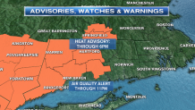
The storms came on a day that will likely end up as one of the top five hottest for this summer season for New England. Certainly for the combination of heat and humidity. The heat index or ‘feel-like' temperatures are approaching or surpassing 100 today in southern New England. Even communities that do not have National Weather Service heat advisories issued will be close to advisory levels. Following safety guidelines of a heat advisory is smart.
Here is some safety information from the National Weather Service when they issue a heat advisory:
Local


A heat advisory means that a period of hot temperatures is expected. the combination of very high temperatures and high humidity will combine to create a situation in which heat illnesses are possible. Avoid prolonged work in the sun or in poorly ventilated areas. Drink plenty of fluids, stay in an air-conditioned environment, stay out of the sun, and check in on relatives and neighbors.
Take extra precautions if you work or spend time outside. When possible, reschedule strenuous activities to early morning or evening. Know the signs and symptoms of heat exhaustion and heat stroke. Wear light weight and loose fitting clothing when possible and drink plenty of water.
To reduce risk during outdoor work, the occupational safety and health administration recommends scheduling frequent rest breaks in shaded or air conditioned environments. Anyone overcome by heat should be moved to a cool and shaded location. Heat stroke is an emergency - call 911.
Climatologically speaking, mid-July has the highest afternoon high temperatures. In August, cold fronts coming down from Canada arrive with air masses containing a stronger chill. So, today, with 90s on the thermometer and dew point temperatures near 70 (like the sub-tropics), we need to take some precautions.
Seniors and those with respiratory distress or illness are most at risk with this level of heat and humidity. Breathing becomes more difficult in this weather and to add to this, an air quality alert is in effect for southwest Connecticut. Low level Ozone will reach unhealthful levels later today. Ozone is a lung irritant and adds another level of concern for those with lung issues.
Drink lots of water and do what you need to in order to keep the body cool. Taking a few measures to keep you and the family safe can make a difference.
Severe Storms:
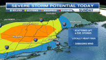
The Storm Prediction Center has upgraded parts of New England to ‘Enhanced’ for severe storms today. This means strong thunderstorms have a greater potential to reach severe status with damaging wind of 58 mph or greater. Severe storms today will also be more numerous. Areas in the enhanced region are seen on the map including most of NH and VT as well as western and central Mass. Even areas outside the orange shaded region can have severe weather. The key is, when thunder roars, go indoors.
Keep tuned in for weather updates throughout today and into tonight as severe and strong storms may continue though midnight! Remember, the lowest level of your home is always safest during a severe storm. A tornado is not necessary to bring a tree limb or entire tree down on one’s home. Mobile homes and campers of course, are not safe and lightning is always dangerous even after a storm has passed. It’s best to wait until you do not hear thunder for at least 15 minutes before venturing outdoors after a thunderstorm. You can track storms with us here on our website or our mobile app with our interactive radar. Have a safe day!
