
The rain continues to fall across most of New England on this Thursday. The showers will be heavy at times as Zeta passes to our south this evening.
Another low pressure system from the southwest will then bring in more rain overnight and colder air that switches us from rain to snow by Friday morning. All the precipitation moves out west to east Friday afternoon.
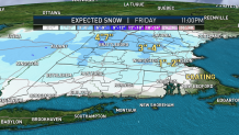
Precipitation Timing
The rain is already here and will stay steady to heavy all night. We expect the South Coast, Cape Cod and the islands to stay all rain through the duration of the storm. Higher elevations will see a changeover from rain to a mix then snow around midnight.
The rain/snow line will head southeast and as far as a Boston, Providence, Hartford line by mid-morning Friday. Through late morning, snow is expected to accumulate on grassy surfaces, but the farther inland and higher in elevation you go, the more snow will impact road conditions.
Snow Totals
Our sun angle is the same now compared to mid February, so snowfall accumulation isn't unheard of this time of the year. We do anticipate light accumulation for many areas Friday late morning.
Around Boston, Hartford and Providence we expect a coating to 2 inches of snow. In southeastern Massachusetts, southern Rhode Island and southern Connecticut we will see scattered coatings. In the Worcester Hills, southern New Hampshire and Berkshires we expect 3-4 inches of snow. The southern Green Mountains may get 4-7 inches of snow in the higher elevations.
Rain Totals
One to two inches of rain is forecast for the southern two-thirds of New England through Friday afternoon. Even though this is a lot of rain, this won't bust our drought conditions, which remain unchanged from last week.
Wind
Our wind cranks up this evening and overnight with a northeast, north wind. Peak gusts will be 40-50 mph from midnight to 7 a.m. on Cape Cod and the islands. Gusts of 20-40 mph will be found around interior southern New England and this is why we expect some power outages.
After the rain and snow is long gone, Friday afternoon we dry out a bit but it stays chilly with highs in the mid-30s. Friday night a deep freeze will create slick spots as temperatures fall to the 20s for all.
Chilly air remains for Halloween with highs in the 40s, but we keep it sunny. Highs reach the mid-50s Sunday as we fall back one hour that morning. Earlier sunsets and more cool temperatures next week will make it feel like an abrupt jump to late fall/early winter.
There are a couple of systems we are watching, one Sunday night and one Tuesday that may bring a rain to snow mix for some. Stay tuned!
