
It will be a quiet stretch of weather the next few days, with a big area of high pressure building into the Northeast.
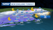
The wind continues to add a bite to the air, but will gradually diminish throughout the day Monday. Expect mostly sunny skies and near seasonable high temperatures in the 30s (20s north).
With clear skies and a light wind Monday night, overnight lows will drop into the teens and single digits for many, and even sub-zero in parts of far northern New Hampshire and Maine.
Get New England news, weather forecasts and entertainment stories to your inbox. Sign up for NECN newsletters.
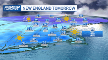
We’ll make a decent rebound Tuesday, into the 30s again (20s far north) under ample sunshine.
As high pressure slowly shifts east through midweek, we’ll see a gradual but noticeable warm up with highs either side of 40 by Wednesday and into the 40s on Thursday.
Local


Our next disturbance will approach by Thursday late day, allowing for an increase and clouds and a chance of some showers rain and snow by evening in western New England. We’ll all get into the threat for showers Thursday night: with marginal temperatures we may get some wet snow mixing in through the interior before a quick changeover to rain.
Areas of rain will continue on Friday, with snow confined to far northern New England and the mountains, where several inches could accumulate by Saturday morning.
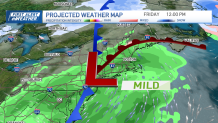
Otherwise, the weekend looks fairly quiet, with highs either side of 40 and the chance of a passing snow shower Saturday.
A push of mild air will arrive to start next week with highs expected to be in the mid 40s to low 50s by Wednesday. The warmth with come with an increasing risk of rain showers Tuesday night into Wednesday as seen in our exclusive 10-day forecast.
