
A significant storm will be impacting New England starting tonight, but the main impact of the storm will happen on Tuesday. Luckily, for many across New England will be simply dealing with a windswept rainstorm. But for those of us who live in Northern and Western New England, there is the potential for a heavy wet accumulating snowfall. This is a storm which will come with a variety of hazards, with impacts which could last through the week as an upper level low becomes cut off and sits over us into next weekend. This upper low will provide instability with cold air aloft, and lift in the atmosphere to trigger more scattered rain and snow showers which will last on and off through Sunday.
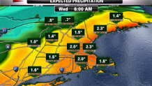
PRECIPITATION
Very light scattered rain and snow showers will develop late Monday and continue into Monday night. A concern is for pockets of freezing drizzle to develop on cold surfaces this evening in colder interiors. Rain will quickly spread into New England Tuesday, with the heaviest rain expected midday into the afternoon, with the chance of an embedded thunderstorms in SE MA. A Flood Watch has been issued for all of CT, all of RI, and eastern MA. Rainfall totals of 1.5-3" of rain are expected, most of which will fall withing a 6 hour window. Heavy rain Tuesday afternoon could lead to ponding on roadways and minor urban flooding.
STRONG WINDS
The High Wind Watch includes the entire east coast of MA, Cape and islands and the south coast of RI. Strong east winds could become damaging wind gusts 50 to 60 mph are possible along the south coast Tuesday morning, shifting northward, reaching Cape Ann late Tuesday afternoon or early evening. This core of strong gusty winds will shift northward to the coast of Maine Tuesday night and Wednesday.
MINOR COASTAL FLOODING
Seas will quickly build to 10-15 feet off the coast Tuesday. Rough surf with Pockets of minor coastal flooding are possible during the time of high tide around noon Tuesday. Surges of 2 to 2.5 ft. above the astronomical tide are expected. East-facing beaches have the greatest risk for the flooding. If the peak East winds happen during this midday high tide, there may be a few locations which may experience moderate coastal flooding. Other high tide cycles Tuesday Night into Wednesday may still provide some splashover and erosion due to high seas and tides running astronomically high.

SNOWFALL
The National Weather Service has expanded a Winter Storm Watch into Franklin, Hampshire, western Hampden, and northern Worcester Counties in western MA as well as Berkshire County. The Watch also includes Vermont, Northern New Hampshire and Northern interiors of Maine. Icy areas due to freezing rain/drizzle are also included in the watch. Areas in the watch...especially north have the potential for 6 or more inches of snow. Our current estimates have the heaviest snow likely in the Northern and Western Mountains. The precipitation will start off as an icy mix Tuesday morning before changing over to a heavier snowfall during the afternoon in the NW mountains. Warmer air will try to mix in Tuesday night where snow even in the mountains will start to change over to sleet and freezing rain. This will help to keep accumulations on lower amounts. The heaviest precipitation will be over Wednesday with a rainy, sleety mix in the NW mountains. As the storm stalls, another round of precipitation will be directed into Northern New England Wednesday afternoon-night. Colder air will begin to feed back into the storm for additional snows to fall in the NW mountains which will exceed a foot of snow. The heaviest snow will likely fall in southern and central VT and also across Northern Maine and New Hampshire. Where the heavy wet snows fall, obviously travel will become hazardous and there will be the potential for power outages.
