
As the center of high pressure, or fair weather, drifts away from New England, clouds will increase from west to east in our Thursday sky ahead of an approaching warm front moving east from the Great Lakes.
A warm front is the leading edge to milder air, but with the milder temperatures following the frontal boundary, not ahead of it, this does mean precipitation will break out Thursday evening and night in a still-cool air that will be able to produce some snow in addition to rain showers.
The mixed showers arrive to western New England during the early evening Thursday in scattered form, expanding east to the coast by 9-11 p.m. and continuing, off and on, through the overnight.
Get New England news, weather forecasts and entertainment stories to your inbox. Sign up for NECN newsletters.
How much snow will Mass., NH get?
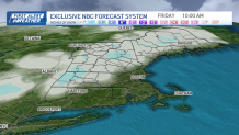
Deep inland, in the northern and western Worcester Hills into south-central New Hampshire, a coating of snow on the grass is possible overnight Thursday night, while northern and western New England will see periodic light snow continuing into Friday, dropping a broad one to two inches with locally higher amounts in the mountains.
So, while a quarter to half inch of rain will fall in southern New England and points south of about Concord, New Hampshire, this event should help, not hurt, northern and western ski areas, with a bit of natural snow falling on an already snow gun-fortified base that built substantially over this past, cool week.
A cold front associated with the weak storm will cross New England from northwest to southeast Friday, ending precipitation by early afternoon north and west, and kicking rain showers out of eastern Massachusetts by around suppertime Friday.
Weekend forecast
Local


This opens the door to a cool, fair and breezy Saturday, with gusts to 35 mph likely to cause a few summit chairlift holds in the mountains and creating a nippy feeling through the day for all of us. Sunday will continue the cool and fair weather, though the wind will be noticeably lighter as we await a new warm front, set to arrive Sunday night into Monday morning.
Spring-like temperatures next week
Yet again, the push of new, milder air will bring some snow and rain showers to New England Sunday overnight into early Monday, then the door opens to daytime high temperatures in the 40s and 50s all of next week, more typical of early April!
This milder pattern does come with an increased chance of rain showers, particularly around midweek, and will make for a spring-feeling return to school for kids that were on vacation this past week!
