
A classic nor’easter is heading our way for Tuesday, in the meantime we have pleasant temps and a calm forecast Monday to prepare for the storm.
Monday and Monday night
A near calm breeze from the north and mild temperatures will be around for Monday. Highs reach the mid 40s to around 50 in some places. Clouds increase from the southwest to northeast as temps drop to the low 30s overnight.
Get New England news, weather forecasts and entertainment stories to your inbox. Sign up for NECN newsletters.
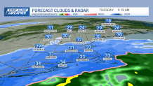
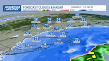
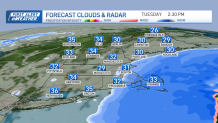
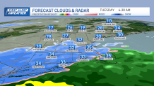
Storm timing
Local


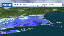
Our storm strengthens rapidly off the Delmarva Coast Monday night into Tuesday. As it does, it wraps in some cold air and brings in ripping snow from morning to early afternoon across southern New England. The snow begins across Connecticut first, with a mix at the coast predawn. By sunrise, the snow is in Boston and accumulating fast. The worst of the snow is from 7 a.m. to 3 p.m. for most. Cape Cod even swaps over to snow by late morning. The snow tapers after 2 p.m. as the storm quickly heads out to sea by dinnertime, and that's when the last snow exits eastern Massachusetts.
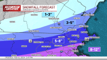
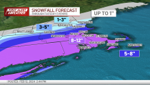
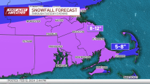
Snowfall totals for Mass., NH
With snowfall rates of 1-3 inches per hour, we expect whiteout conditions. Plus the snow combined with the wind, near-blizzard conditions can be expected along the south shore to Cape Cod. Generally 8-12 inches of snow will fall from Tuesday morning through early afternoon in southern and central New England. Boston, Hartford, Framingham, Southbridge, Plymouth and South Shore around 10 inches. Around 12 inches for Norwich and New Haven, Connecticut, most of Rhode Island, to Bristol and interior Plymouth county in Massachusetts. Cape Cod & Islands 5-8 inches. About 6-8 inches for the Merrimack Valley, Worcester County, and the Berkshires. Around 4 inches from Manchester to Brattleboro, Vermont, and a sharp cutoff north. Northern New England misses out on this particular storm.
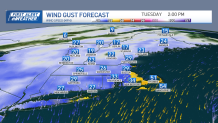
Wind gusts could cause power outages south of Boston
As we wake up Tuesday morning, the winds are already gusting 20-40 mph from the east, northeast at 8 a.m. The northeast wind strengthens a bit around 30 mph inland and 40-60 mph at the coast. Isolated power outages and damage will be found along the coast where we have the heavy pasty snowfall combined with the winds.
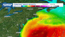
Coastal flooding expected in Boston, South Coast
Our tides are astronomically high due to the new moon this weekend. Wave heights will be around 10 feet offshore, with a strong northeast wind so this will push water onto our coast. Beach erosion and flooding will be a problem this time around. Tuesday afternoon's high tide is forecast to be near moderate flood stage for several places like Boston, Scituate, down to Nantucket. Storm surge approximately 2-4 feet on top of the high tide is forecast. The flooding will be a couple hours before and after high tide, which is around 2 p.m. for Boston. The waves and a northwest wind will remain for the overnight high tide Wednesday at 2 a.m., with tides still running high, so minor flooding is possible.
10-day weather outlook
Wednesday brings us quiet weather with sun, but gusty northwest winds between 30-40 mph. Highs will stay in the 30s for most after morning lows in the 20s and icy conditions. Make sure you have your sunglasses, it is extra bright! The fresh snowfall allows for extra sunlight reflection (high albedo). Fresh snow and sunshine creates extra bright days. A few minor systems move by the northeast (in from the northwest) and so scattered snow showers continue off and on in the forecast Thursday through the weekend. Temperatures remain in the 30s for the rest of the 10-day forecast.
