The first weekday of each month, our viewers and readers know to count on our WeatheRate Certified Most Accurate in Boston First Alert Weather Team for a look at the month ahead.
The first day of December, however, finds us not only at the start of a new month but also the beginning of a new season. The calendar may not show astronomical winter until the Winter Solstice on Tuesday, Dec. 21, at 10:59 a.m., but meteorological winter starts on Dec. 1, and our meteorologists have plenty of thoughts on the season ahead.
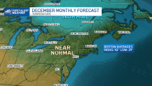
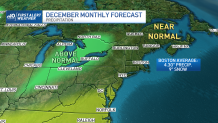
First, some perspective: after three months of warmer than normal temperatures in the Boston area, November’s average temperature came in precisely at normal – 44.7 degrees. Precipitation was below normal by a wide margin, with only 1.34 inches, compared to the normal value of 3.66 inches, with no observed snow falling, which is shy of the normal of 0.7 inches in Boston.
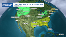
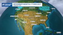
On a bigger picture, most of the United States has been warmer than normal for several months and we don’t expect that to change. December likely will find most of the country warmer-than-normal, although what’s true for the country doesn’t always hold true for New England. The latter half of November has shown an increasing amount of cold air in Alaska, and this cold has shown a tendency of dropping into Quebec – a pattern doesn’t look to stop. The big driver in this weather pattern has been a recurring, strong, stalled upper level storm (a jet stream trough) over the Norwegian Sea and Barents Sea in Northern Europe. With this feature not breaking, the jet stream across the Northern Hemisphere has fallen in lock-step and doesn’t appear to be budging soon.
Get New England news, weather forecasts and entertainment stories to your inbox. Sign up for NECN newsletters.
The result over the last few weeks – and likely through December – is a steady feed of storms off the Pacific Ocean into the northwestern corner of the United States, running east across the Great Lakes and redeveloping near the Northeastern Seaboard.
Looking a month ahead is one thing – looking an entire season ahead is more involved.
U.S. & World

Meteorologist Pamela Gardner has been keeping a close eye on Pacific Ocean water temperatures: “La Niña has strengthened in the last few weeks. This means colder than normal sea surface temperatures. Its counterpart is El Niño, which is warmer than normal sea surface temperatures. With La Niña, we typically see colder and wetter weather in the northeast during the winter months.”
Pamela’s not alone is watching the opposite ocean – meteorologist David Bagley keys in on the same signals from nature: “We can’t discount this year’s La Niña, which may drive the jet stream further north, but a dip in the jet stream out of the Great Lakes from time to time with extremely cold air spilling over may be all we need to allow for some Clipper-type systems starving for attention as they dive out of the Lakes region and into the Atlantic south of New England and potentially develop into snow makers.”
Meteorologist Pete Bouchard has been forecasting New England weather for decades, and he’s seen seasonal forecasts pan out -- and miss the mark. Pete reflects the sentiment of our entire weather team: “I’m not a huge fan of seasonal (read: winter) forecasts. That said, I know people love them and I’m happy to oblige. So, let me give you my two cents: prepare for the warm/cold extremes with a hard lean toward the warm at times and a slightly above normal snowfall. I’m hedging my bets that snowstorms will all overachieve, with a couple of 1-plus footers in there for good measure. In essence, it should be like all our past winters of late (minus 2015, of course), and a slow warmup in the spring…which may be when we really get rolling in the deep (snow).”
There’s certainly plenty of evidence to support Pete’s outlook of spring snow – in fact, climate change has altered modern winters in the northeast to make “bookend snow” – at the start and end of winter – more commonplace than 20 or 30 years ago, with spring becoming a focus for snow in a warming climate.
How has climate change altered the winter pattern? For generations, a mass of cold air referred to in meteorology as the “Polar Vortex” resided in high latitudes, bottling up some of the coldest air on earth during the winter months. On occasion, the Polar Vortex would wobble or dip south, thrusting a mass of cold southward for arctic outbreaks.
You might remember hearing lots about the Polar Vortex and extreme cold in the Northern United States back in the winter of 2013-14. What’s interesting is that wasn’t the Polar Vortex of old – instead, the abundance of warmth in northern areas and around the North Pole has caused the Polar Vortex to break into pieces – unstable, wobbling bundles of cold that often break into two or three discernible, smaller chunks rather than one solid mass. While this can mean bouts of intense and abnormal cold for those under each piece of the Polar Vortex, the very nature of these smaller, wobbling masses is proof positive that a warming climate has changed our winters.
So what we find in winters of late is persistent bands of heavy snowfall occurring on the edges of these meandering, relatively small masses of intense cold air. One perfect example of the impact of falling under these heavy snow bands is our southern New England winter of 2014-15, where the seasonal snowfall for someplace like Boston was shattered in a mere two months: “We had 60s recorded on Christmas Day... then the snow blitz from January to February when Boston had 99.1 inches of snow, and over 110 inches of snow for the entire winter,” recalls Pamela. This crush of snow unfolded as abundant warmth fought to scour out shrinking cold.
This leaves the stakes high in a seasonal forecast: nail the band of heavy snow and you’ve nailed the winter forecast. If you set up north of it, you may end up colder-than-normal and drier-than-normal, while south of it, the abundant warmth of the Northern Hemisphere rules with limited snow and above-normal temperatures.
So when you put together our First Alert Team forecast for winter 2021-22, what you’re seeing here is an agreement between us that we very well may be near one such heavy snow band this year. The chances of something like February/March of 2015 setting up over Boston again are very limited, but this team forecast shows the door is open for the northeast to see plenty of snow.
Whether the axis of heaviest snow sets up in Ski Country of northern New England, across southern New England or from New York and Pennsylvania to New Jersey will hinge on exactly how firmly cold air over Quebec holds against the active northern U.S. storm pattern, but our team believes that’s close enough to bet on a near or slightly snowier winter than normal for much of New England.
Taking it a step farther, the implication is for many events to be characterized by the greatest opportunity for snow at the start of storms, particularly in southern New England, with the abundant available warmth in the rest of the country eager to make inroads and change snow to a mix or rain, with the longest duration of snow found the farther north one is. Often, storms like this can drop heavy snowfall rates in the first several hours, then taper markedly thereafter, making for blitzes of plowing rather than multiple marathons.
That said, there is one other hallmark of modern fall, winter and spring. On the cusp of the migrating, wobbling clusters of deep cold, we occasionally see slow, large, strong storms – our recent October nor’easter was a classic example of this. They are few and far between, but a steadily rising sea-level has ensured such storms have a harsh impact with regard to coastal flooding
Combining all of these factors, our NBC10 Boston, Telemundo Nueva Inglaterra and NECN First Alert Weather Team expects warmer-than-normal temperatures when averaged over the December/January/February timeframe (except perhaps for extreme northern New England near the border with Canada), above-normal precipitation for most of us and near to slightly above normal snowfall for the Boston area, with an even better chance of above-normal snowfall in central and northern New England, including ski and snowmobile country.