
Big changes on the way Sunday as an arctic cold front gears up to barrel through the region, ushering in a much colder airmass which will stick around for the foreseeable future.
Clouds will thicken this afternoon with snow showers and snow squalls developing ahead and along the frontal boundary, precipitation may be a mix of rain and snow south of the city at the onset.
Some of the squalls may be briefly heavy with gusty winds and low visibility, resulting in slippery travel.
Get New England news, weather forecasts and entertainment stories to your inbox. Sign up for NECN newsletters.
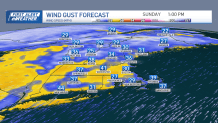
Keep in mind, unless you’re tracking these squalls, they will seem to come out of nowhere, so please take it slowly if you encounter them…sometimes pulling over and waiting it out, if safe to do so, is the best course of action.
U.S. & World


The timing of the front brings it through northern and western New England early this afternoon, mid-afternoon into the evening eastern areas, and off the coast by early tonight with clearing skies and colder temperatures.
Highs reach the upper 30s to around 40 south this afternoon, 20s and 30s north. Lows tonight mostly in the low 20s south, teens north.
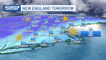
Cold air settles into the area Martin Luther King Day with plenty of sunshine along with temps barely breaking freezing south, 20s north.
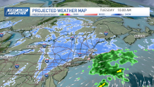
A storm system exits the mid-Atlantic coast Monday night and tracks off the New England coast Tuesday and Wednesday. Right now it looks like we could see a light accumulation of snow, but still some uncertainty in its timing, track, and intensity at this point, but we should have a better lock on it this evening.
Beyond that, we stay cold right through the end of the work week with another shot of snow by the weekend which is featured on our Exclusive 10-Day Forecast.
Have a great rest of your Holiday Weekend!
