The pattern has finally relaxed. And warmed as evidenced by our widespread 70s Monday. While the next few days are still above normal, we're at the end of the line with the summer warmth.
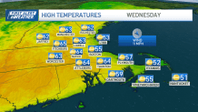
Cooler air in the upper atmosphere will drop us to the mid/upper 60s Tuesday. And Wednesday's sea breeze will ensure that the 60s are absent along the coast in the afternoon. Brisk breezes continue Tuesday, especially in the afternoon, and then back off a bit Wednesday.

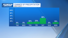
Despite Mother Nature's best efforts, however, the showers will be elusive in the coming days.
Call it a determined batch of dry air holding them off or really feeble weather system without a lot of gumption. Either way you slice it, this is a stark contrast to our relentless wet spell.

We could go several days without a steady, driving rain (quick-hitting showers don't count here). In any event, we'll watch the fire danger and track the temperatures in the coming days.
Weather Stories
Enjoy the quiet spell.


