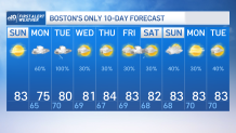
Stepping out today has been a delight, its bright, its dry and temperatures are topping in the mid-80s.
Our luck will run out tomorrow as the first rounds of rain will be pushed in by a warm front followed by more rain & storms Monday night-Tuesday.
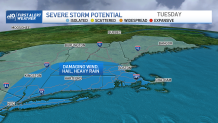
A few storms may become strong to severe for which we’ll keep an eye in the sky and a look out for the chance of flash flooding in northern New England as several rounds of heavy rain will likely push over parts of VT-NH and the west.
Get New England news, weather forecasts and entertainment stories to your inbox. Sign up for NECN newsletters.
So, as we hop into the evening and overnight hours, clouds will slowly increase and humidity will rise.

Our temperatures tomorrow will stay in the upper 70s with the showers entering CT & western MA early morning with additional rounds into central and eastern MA from the mid-morning hours into the second half of the afternoon.
That second round Monday night into Tuesday will carry heavy rain with storms that become scattered and cover more terrain expanding into northern New England.

There’s a chance for isolated storms to become severe providing hail, strong wind gusts, frequent lightning along with possible rotation.
Wednesday afternoon will dry us out into Thursday but we’ll wrap up the work week with a new chance of rain. Temperatures, however, will stay close to the average low 80s.