
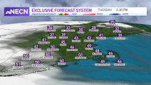
High pressure builds into New England Tuesday from the north, bringing slightly cooler temperatures than we saw Monday. Nevertheless, they are still a few degrees above normal for this time of year.
Other than a few clouds passing by from time to time, the day will remain quiet, with high temperatures reaching the upper 30s north, mid to upper 40s south. Factor in the breeze from the north and it will feel a bit cooler.
What you won’t notice today is that we're adding a few seconds to Tuesday evening’s sunset. As a matter of fact, sunsets will continue to get later from here on through June.
Get New England news, weather forecasts and entertainment stories to your inbox. Sign up for NECN newsletters.
However, we continue to lose daylight on the morning side right through the winter solstice on Dec. 21. Tuesday's sunset is at 4:12 p.m., after the earliest of the year on Monday: 4:11 p.m.
Temperatures will drop overnight into the mid 20s to low 30s south, with 20s in much of northern New England and teens across the far north, along with some high, thin clouds increasing late.
Wednesday will be cool with clouds increasing ahead of a system over the Great Lakes, which will track north of the region Wednesday night into Thursday. The system’s warm front will push through the region Wednesday night into early Thursday, bringing with it rain showers for southern areas and a brief mixed bag of precipitation at the onset through central and northern New England. There shouldn’t be any issues due to mild air winning out quickly as the warm front moves through the region.
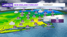
On Thursday, we are left with a couple of lingering morning showers, but the afternoon promises to be very mild along with a gusty southerly wind. Highs Thursday will reach the 60s south, 40s and 50s north.
Enjoy the warmth Thursday, because Friday and beyond we will see the pattern shifting to a colder and somewhat active one. As a matter of fact, our First Alert Team is watching a couple of systems that may bring some rain and snow to the region through next week.
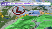
The first one arrives Saturday and we will likely be tracking a rain/snow line over the area as the system moves through during the day. The second one comes around Monday night into Tuesday and looks a bit colder.
Weather Stories


Still a lot of uncertainty, but if you’re holding on for a white Christmas, these will be something for you to watch. Stay tuned.
