We kick off the week with hazy, hot, and humid conditions. The heat wave took off yesterday for some, not for Boston. We hit 89 (heat index 94) and Worcester made it to 85.
Some locations did make It to 90 or above:
- Springfield, MA - 90
- Hartford, CT - 90
- Concord, NH - 92
- Manchester, NH - 91
Heat advisories are in effect for most of New England. The temperatures in the lower 90s, along with high humidity, generates a heat index in the mid 90s to 104. The heat index measures the impact on the body. There may be the possibility of an excessive heat warning to be issued for some if the heat index values reach 105.
Get New England news, weather forecasts and entertainment stories to your inbox. Sign up for NECN newsletters.
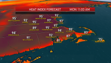
With these heat index values and high temperatures, expect little relief during the overnight hours. Low temperatures may stay above 70, specially tonight into tomorrow.
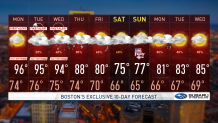
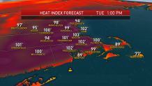
The front generating those thunderstorms to our west is going to slowly ease in from the north and west over the next several days. That will continue to draw air up from the south and west with warmer temperatures today and over the next couple of days, more like the mid 90s today through Wednesday. The heat index will surpass 100° at times during the afternoon.
The threat for thunderstorms is still fairly small tomorrow, but the threat becomes greater starting Tuesday. The presence of cloud cover and storms may impact how warm a specific location may get.
The heat will gradually ease from north to south in the middle of the week. For central and southern New England, we will likely top 90° Wednesday and Thursday, making this a four or five-day heatwave.
Also at that time, the thunderstorm threat really increases with the potential for some damaging storms and localized flash flooding because there’s so much moisture in the atmosphere.
The early call for Independence Day Weekend is not that great. It looks like the front of stalls nearby with a threat for showers and thunderstorms continuing even though the temperature has cooled into the 70s with more of a wind from the east Friday and Saturday. Hopefully that outlook will be improving as we continue to monitor the changes in our First Alert 10-day forecast.