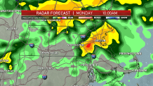
A flash flood watch remains in effect for most of Massachusetts and parts of Connecticut and Rhode Island. We’re tracking heavy rain impacting our morning commute.
Areas most affected are across northern Massachusetts from the Pike to the Route 2 corridor. We are concerned with the torrential downpours first part of today. We urge you not to cross or drive through flooded roads -- turn around don’t drown.
In Lynn, Massachusetts, the fire department responded to Alley Street Monday morning after flooding left drivers stranded.
Get New England news, weather forecasts and entertainment stories to your inbox. Sign up for NECN newsletters.
This heavy rain developed overnight last night, bringing the threat for flash flooding given the recent rain and saturated grounds. All this activity is due to an approaching warm front.
We are under the gun with this heavy rain through around noon. Expecting 1-2” of rain once this system moves out. We should see an improvement as the afternoon progresses across Massachusetts.
As we head into the afternoon, we’ll see another round of rain move into and impact Connecticut and Rhode Island. This is the area of concern with the risk for severe thunderstorms.
The window for this potential is 2-8 p.m. These storms could bring excessive rain and damaging wind. The Storm Prediction Center is not ruling out a brief tornado.
Looking ahead to the middle to end of the week, we’ll be entering a typical summertime pattern with warm and humid conditions.
Daytime heating will give way to daily chances for isolated to scattered showers and thunderstorms. Mid to late week temperatures have high in the 80s with heat indices in the 90° range.
Please stay safe and don’t attempt to pass flooded roadways.