
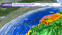
We’re continuing to monitor a major nor’easter that will impact the region late Friday night and through much of Saturday.
Thursday evening and overnight we’ll see clouds on the increase with temperatures dropping into the single digits and teens north, teens and low 20s south. A cold front will slide through the area Friday and stall over southern New England during the day bringing with it a few snow showers and flurries, mainly across Connecticut, Rhode Island, and the Cape. About a coating to an inch is possible, mostly over southern Connecticut and western Rhode Island, but shouldn’t be too much of an issue. Highs tomorrow reach the mid 30s south, 20s north.
A major nor'easter develops late Friday into Saturday
Get New England news, weather forecasts and entertainment stories to your inbox. Sign up for NECN newsletters.
The big story is the major nor’easter which is expected to develop off the mid-Atlantic coastline and track northeastward late Friday night and during the day Saturday. It is becoming more likely that we will see major impacts here in New England from this storm. Right now, the strongest part of the storm and the biggest threat of outages comes between 5 a.m. and 2 p.m. Saturday.
How much snow are we getting this weekend?
In terms of snow, it is looking like coastal New England will see the most snow with 14-20," with some isolated chances of up to 28". We still may have to fine-tune the precise amounts since we are still 24-48 hours away from the first snowflakes!
Our in-house forecast model has been very consistent this week and continues to stay the course with these totals. We’ll also be dealing with gusty north/northeast winds which may cause power outages, especially along the coastline where winds may gust over 60 mph, perhaps even over 70 mph across the Outer Cape.
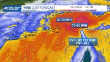
Minor to moderate coastal impacts are expected as well being so close to an astronomical high tide. Our First Alert Team will continue to update the forecast as new information comes our way. Stay safe out there!
