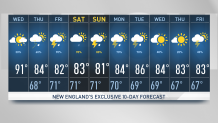
Scorching heat takes us to the 90s today along with bright skies and high humidity. Isolated downpours and embedded thunder is possible across northern and western New England today.
Severe thunderstorm warnings were issued in parts of Maine and western Massachusetts Wednesday afternoon, but they have since expired.
Click here to see active weather alerts.
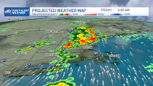
More impactful precipitation, however, is expected Thursday into Friday.
Get New England news, weather forecasts and entertainment stories to your inbox. Sign up for NECN newsletters.
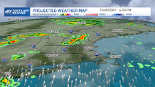
The threat for localized heavy rain is what keeps our eyes on western New England tomorrow into Friday with our next frontal boundary pushing in scattered showers and storms capable of producing over an inch of rain per hour.
The tropical set up is what leads to heavy rainfall capable of winding up in a localized spot, which leads us to flood warnings. Some Rivers and streams from VT to the CT River are still trying to recede.
Winooski River at Essex junction in VT has experienced major flooding with over 22 ft and is slowly trying to reduce. When adding Thursday into Friday’s rainfall, the problem will grow back up again.
Today’s storms & downpours are mainly from southern VT, to the Berkshires and along southern NH. Tonight should be quiet and mil with lows in the 70s.
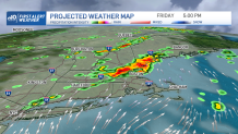
Tomorrow will be another warm and humid day with highs in the 80s but that’s when our boundary rolls in pushing scattered showers & storms that should last into Friday as the boundary retracts northward late in the week enhancing more heavy rain.
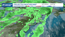
The weekend features periodic showers and thunderstorms that should continue into our following weekend. Temperatures next week should stay warm with highs in the 80s.