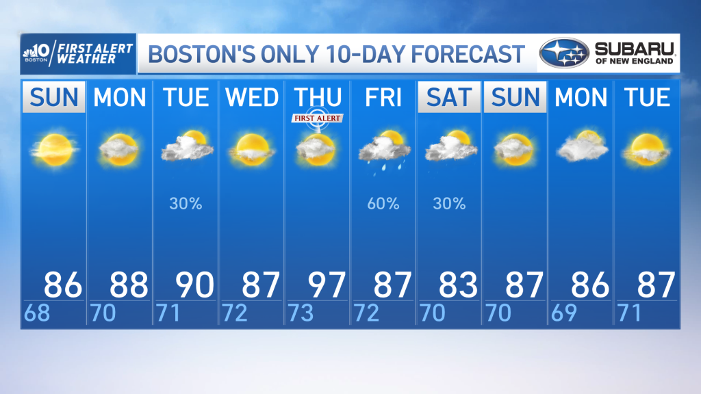
From the NBC10 Boston First Alert Weather Center… Today: Mostly sunny, very warm, low humidity. Highs mid 80s, sea breezes coast. Tonight: Increasing clouds, bit muggy, isolated shower south. Lows upper 60s Monday: Very warm, sun and clouds, isolated PM shower. Highs mid to upper 80s. Cape Cod Radio Forecast: Today: Mostly sunny and comfortable. Highs in the lower 80s. Tonight: increasing clouds, chance for showers late, more humid. Lows mid to upper 60s. Monday: An early shower, clouds and sun, humid. Highs low to mid 80s.
Our fantastic weekend forecast continues through Sunday.
It’s a crisp start to the morning with dewpoints in the upper 50s, and temperatures in the upper 60s. There isn’t much moisture in the atmosphere, so we’re in store for a sunny day. Highs Sunday are in the mid to upper 80s for most.
Monday is similar, as moisture returns with a southerly flow as we start the work week.
Highs are near 90° on Tuesday. A weak disturbance moves through on Tuesday with a brief shower chance, primarily across northern New England; a better chance for showers and storms will come later in the week with a stronger complex.
Get New England news, weather forecasts and entertainment stories to your inbox. Sign up for NECN newsletters.
Southerly flow strengthens as an area of high pressure brings in humidity and above average temperatures, roughly 10-15° above daily average. Area-wide high temperatures on Thursday are in the mid-to-upper 90s.
With the above average heat and added humidity, it’s possible a few heat advisories will be necessary. But the excessive heat is short lived, as a front slides across New England behind the heat with widespread showers and thunderstorms. This would bring beneficial rain to the region, as July ended as the third-driest on record for Boston.