
For a relatively quiet pattern, there seems to be a lot going on. Feeble showers are trying to make progress across southeast Massachusetts Thursday. While they won’t amount to much, they keep the skies busy in many parts of the state. Temperatures actually mount a comeback too. Highs "soar" back to the mid 80s away from the coast, and near 80 at the water’s edge.
We’re promising drier air for the weekend, but in order to get there, we have to push another front through the area. That comes Friday with another chance for a few showers in the afternoon. Again, it doesn’t amount to much of anything for any one town or city, but it keeps interesting in terms of tracking showers.
Get New England news, weather forecasts and entertainment stories to your inbox. Sign up for NECN newsletters.
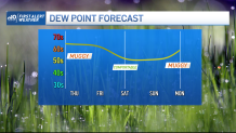
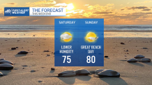
Varying sun and clouds for Saturday and Sunday, with pleasantly dry air and occasional sea breezes. It’s the perfect recipe for a mid-August weekend, and badly needed as we catch our breath after the recent hot streak. While we enjoy the weather on the ground, the upper atmosphere will be conspiring to bring us a spell of wet weather next week.
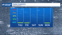
A weak low will gradually "close off" high up in the atmosphere and start drawing in moisture from the Deep South. This will manifest itself with some increase in clouds Monday and developing showers late Monday night. This could (hopefully) form a surface storm system that crawls across New England through Wednesday of next week. This *could* be our best chance at soaking rain in months! (Apologies to those with vacation plans.) Humidity climbs a bit too, but it’s tolerable as temperatures hold in the 70s. Cross your fingers this continues to materialize and evolve in the coming days. The groundcover and soil are crying for a quenching rain.
