
Our storm has left a legacy of snow and tornadoes from southern California to the Southern Plains.
Now it takes aim at us.
When Will the Wintry Conditions Begin in New England?
We’re expecting the snow/mix/rain to break out late Friday evening (wiggle room here) between 10 p.m. and midnight. At first, it’s a mix of rain (coast) and snow (most everywhere else). Later into the night, the upper levels of the atmosphere will be warming up, turning us to mix and rain. Heavy precipitation will be falling overnight, along with an increasing easterly wind.
Get New England news, weather forecasts and entertainment stories to your inbox. Sign up for NECN newsletters.

By early Saturday morning, the wind will be howling from the east (along the coast) and the snow amounts will be paltry for many spots. From northern Massachusetts to southern New Hampshire, however, we may have something to plow or shovel.
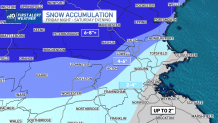
How Much Snow Will Accumulate in New England?
As the winds turn to the north later in the morning, however, we’ll see the colder air return to the picture and change most of us over to snow. Give it a few hours, and the snow will migrate all the way to the Cape. However, at that point, the storm will also be starting to wind down. Accumulations will be tricky given the timing of the changeover, the varied accumulations on the front end of the storm, the time of year, the turning of the wind….yeah, I got more excuses than a man going to jail.

Our best effort is displayed in the attached maps. We’re not looking at a lot along the coast (on brand for this winter), but some solid amounts to the north.
Sunday sees us the sun return and the temps return to the 40s. Lots of those temps in the 10 day as well.
Friday night plans look okay in the evening, and more wet than white late night. Saturday night is a little bit sloppier, but the storm will be departing.
Weather Stories

Have a safe, warm weekend.
