
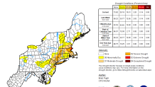
While we’ve certainly seen improvement in drought conditions across the region over the last month especially, there are still many communities in the moderate to severe category. Bottom line? We need rain.
Our next chance of widespread wet weather comes in later this week. While there may be a few showers ahead of the steadiest rain on Thursday afternoon, the bulk of the rain will move through from west to east Thursday night into pre-dawn on Friday. As we hone in on the exact timing in the days to come, we may end up issuing a First Alert for Friday morning if the rain looks like it will impact the morning drive significantly.
Get New England news, weather forecasts and entertainment stories to your inbox. Sign up for NECN newsletters.
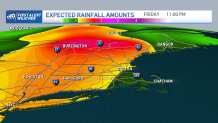
The back edge of the rain will shift through pretty quickly with a drying trend Friday midday along with partial clearing as well. So how much rain should we expect? Our early estimate is for a widespread 1-2”, though some will end up with less, mainly in far southeastern New England and eastern Maine. While there will likely be some localized poor drainage flooding and ponding of water on the roads/big puddles - this system is pretty progressive, so the threat of flash flooding or widespread issues is fairly low.
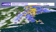
The wind associated with this system is cause for some concern. Ahead of the front, southeast gusts 25-35 mph will be common Thursday afternoon and evening – certainly noticeable but not damaging. As the steadier rain moves in, any downpours and embedded thunder will help in transporting some of the strong wind above the ground down to the surface. The result will be gusts 35-45 mph with isolated gusts to 50 mph. That is when pockets of wind damage will likely result. The timing of the strongest wind gusts will be overnight Thursday into early Friday. Keep in mind, the rain amounts and specifics on wind gusts will be tweaked going forward as we pinpoint down the details of this system.
Weather Stories


Stay tuned!
