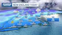
A fresh coating to 2 inches of snow fell overnight. Roads are actually fine Friday morning with temperatures around 32 and the rock salt on the pavement did the job.
Snow showers continue throughout the day in scattered areas as a gusty northwest, west wind takes over. Some more robust snow showers may develop on the backside of the departing low pressure. This would be associated with a Norlun trough and that helps to enhance snow for an isolated area, looking like around mid-coast Maine and islands towards Penobscot Bay.
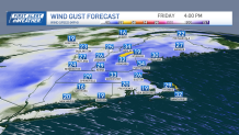
Meanwhile, the mountains continue to see snow showers through the afternoon Friday, leading to additional 1 to 3 inches of snowfall on the peaks. As our wind cranks up through noon Friday, we could see some blowing/drifting snow north, with isolated areas of damage or outages.
Get New England news, weather forecasts and entertainment stories to your inbox. Sign up for NECN newsletters.
The highest winds are expected to be in higher elevations, and across Cape Cod with west winds pushing 50 to 60 miles per hour. By mid-afternoon, the wind dies down and highs top off in the 30s. Friday night, we see lows in the 20s, so it turns icy.
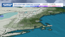
Saturday brings us a chance for light mountain snow, with a system also passing way to the south. Scattered snow showers Friday night into Saturday morning produce coatings to less than an inch.
Temps stay in the mid-30s all weekend and emerging sun returns Sunday. Late Sunday, another clipper system passes to our north and may swing in another quick chance for snow showers from the Mass Pike and areas north.
Highs on Presidents' Day will be around 40 with full sun, a great start to school vacation week!
Temps stay in the low 40s with dry weather through the end of next week. A chance for snow returns by the end of the 10-day.