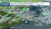
Severe thunderstorms popped up Sunday afternoon across New England, including in Maine — where flash flooding was possible — New Hampshire and southeastern Massachusetts.
See all severe weather alerts in your area here.
Isolated to scattered showers were marching across the region, but a slow-moving cold front was set to usher in drier air Sunday evening with decreasing cloud coverage and lowering dew points through the night.
Get New England news, weather forecasts and entertainment stories to your inbox. Sign up for NECN newsletters.
The rain and showers move out, our temperatures will dip this evening to the lower 70s with decreasing cloud coverage.
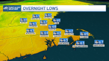
Lows will dip into the lower 60s west tonight, upper 60s for Boston and the coastal communities.
Monday will be bright and comfortable with a light NW flow and dry skies. Monday night will open the gate to clouds marching out of the south coast and rain for early Tuesday.
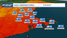
Tuesday’s activity may bring two rounds, with an early push and another one during the late afternoon hours. A storm or two may tag along.
Weather Stories


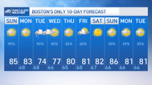
Temperatures will drop below average to the lower and mid 70s in Boston and the coast with upper 70s inland.
The sea breeze will kick in that day keeping temperatures near average through Wednesday.
Wednesday afternoon will dry out in southern New England with highs that slowly climb to the lower and mid 80s through Friday.
However, Friday will be that next round of rain we’ll be keeping an eye out for. A high pressure stalls in the following weekend allowing for a rise in temperatures that will take us to the upper 80s.