
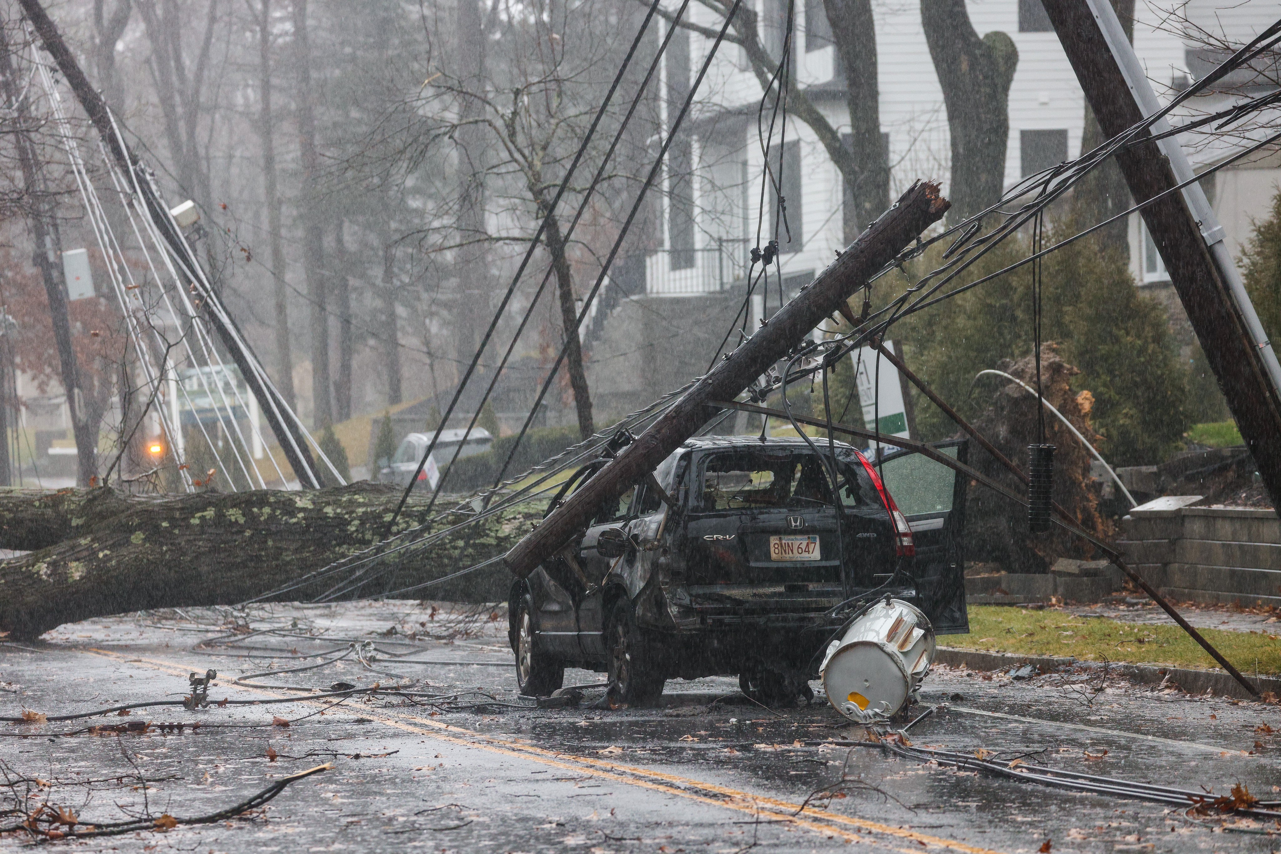
The Boston area was blasted with damaging winds and drenched in rain Monday as a major storm moved through New England.
Winds reached a blistering 68 mph at Boston's Logan airport, where the FAA had to issue two separate ground stops Monday. And that wasn't the fastest wind in the region, according to National Weather Service data — that was at Blue Hill Observatory in Milton, which reported winds up to 90 mph.
More than 3 inches of rain fell in parts of the Greater Boston area, as well.
Get New England news, weather forecasts and entertainment stories to your inbox. Sign up for NECN newsletters.
Use this map to explore rainfall totals from around the region, and scroll below it for a list of the places with the biggest rainfall totals and fastest wind speeds:
More on Monday's storm in Boston
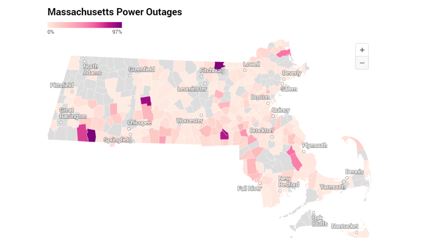

NOTE: The information is separate into two sources, the National Weather Service's regular public information statement and the volunteer storm spotter system SKYWARN.
Rainfall totals around Greater Boston
National Weather Service:
East Framingham 3.16 in.
Norwood Airport 2.74 in.
Bedford Airport 2.67 in.
Worcester Airport 2.64 in
Lunenburg 2.62 in.
North-northwest Lexington 2.58 in.
Lawrence Airport 2.54 in.
Lakeville 2.34 in.
Taunton Airport 2.17 in.
Rockland 2.17 in.
South-southeast Millis 2.2 in.
Norfolk 2.12 in.
Sherborn 2 in.
Hudson 2 in.
Logan Airport 1.65 in.
Eastham 1.53 in.
SKYWARN:
West Roxbury 3.10 in.
Ashfield 4.79 in.
Colrain 3.85 in.
Westminster 3.86 in.
Leominster 3.47 in.
Bolton 3.89 in.
Carlisle 3.39 in.
Chelmsford 3.28 in.
Westford 4.12 in.
Natick 4.03 in.
Acton 3.70 in.
Boxborough 4.10 in.
Framingham 3.05 in.
Burlington 3.65 in.
Haverhill 3.03 in.
Lawrence 3.00 in.
Amesbury 3.38 in.
Huntington 4.54 in.
Holyoke 3.03 in.
Northborough 3.75 in.
Northbridge 4.33 in.
Worcester 3.10 in.
Sutton 3.83 in.
Tolland 4.46 in.
Southwick 3.52 in.
Easthampton 3.22 in.
Florence 3.39 in.
Southampton 3.46 in.
Northampton 3.15 in.
Wrentham 3.00 in.
East Walpole 3.04 in.
Kingston 3.40 in.
Shirley 3.85 in.
Ashby 3.20 in.
Mansfield 3.28 in.
Littleton 3.25 in.
South Natick 3.22 in.
Cambridge 3.11 in.
Agawam 3.44 in.
Dudley 3.10 in.
Wind gusts
National Weather Service:
Blue Hill Observatory 90 MPH
Boston Logan Airport 68 MPH
Nantucket Airport 67 MPH
Norwood Airport 67 MPH
North-northwest Dighton 66 MPH
Hyannis Airport 63 MPH
Plymouth Airport 60 MPH
Martha's Vineyard Airport 56 MPH
Bedford Airport 56 MPH
Beverly Airport 55 MPH
Worcester Airport 52 MPH
SKYWARN:
Milton - Blue Hill Observatory 90 MPH
Mashpee 80 MPH
Rockport - Thatchers Island 75 MPH
Fairhaven - West Island South Beach 71 MPH
Dennis 68 MPH
Boston - Northeastern University 67 MPH
Onset (Onset Pier) 67 MPH
North Dighton 66 MPH
Woods Hole 64 MPH
Fall River - Borden Flats Light 64 MPH
North Weymouth 63 MPH
Hanover 60 MPH
Agawam 60 MPH
Marstons Mills 60 MPH
