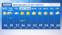
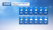
It’s a cool and blustery day across New England on Wednesday. Temperatures this morning were in the in the 20s north, and 30-35 degrees inland, with upper 30s to near 40s near the coast. This afternoon highs will range in the 40s -- we're not watching for any 50s.
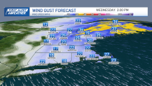
Northwest winds of around 25 to 30 mph are making it feel a lot cooler, especially if you’re under the shade or exposed as the wind chill will range a few degrees cooler than what the thermometer marks.
Thankfully, we’ve got sunny skies to help us endure this cooler than average afternoon. Dew points will remain in the teens to the lower 20s.
Get New England news, weather forecasts and entertainment stories to your inbox. Sign up for NECN newsletters.
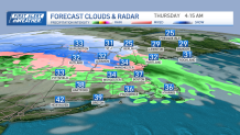
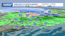
Later Wednesday night and on Thursday, a low-pressure system will bring changes to our weather and more of a wintry turn. The system, currently over the central Plains, will move into the region, causing warming mid-levels to override the cold and dry layer.
This will result in a period of light wintry mixed precipitation to rain. Areas north of the Massachusetts Turnpike and in the hilly terrain may experience some freezing rain and sleet at the onset. Ice accumulations, if any, are expected to be limited to elevated surfaces like trees and bridges but should be less than a tenth of an inch.
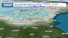
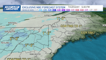
The forecast suggests that the onset of precipitation may begin as early as the pre-dawn hours in some areas north of the Mass Pike, but dry air may delay this, possibly until mid-morning.
The primary precipitation type will be rain, although in the early stages, plain rain could mix with refrozen ice pellets briefly. Any potential icing is expected to affect mainly elevated surfaces, with little impact on paved roads where temperatures may still be mild.
After this bump in the road, dry and quiet weather will sail us into the weekend and the following week. The region will experience a gradual cooling trend from Friday through Monday, with temperatures decreasing.
However, from Monday onward, temperatures are likely to recover and return to more typical for mid-November. Despite these temperature fluctuations, there are no strong signals for significant weather impacts over the next seven to 10 days. Stay tuned to NBC10 Boston and NECN as the First Alert Weather Team will keep you posted.