
A quiet start to the weekend with temperatures on the mild side along with clouds and sunny breaks. Not much in the way of precipitation today except across northern New England where we’ll see a few mountain snow showers and lower elevation rain showers.
Some diurnal showers may develop across central Maine through this evening, otherwise the rest of the six state region looks to be on the dry side with a very isolated shower/sprinkle popping up. Highs reach the 50s south, 40s north and along the immediate coast.
Overnight clouds will hang tough with some areas of patchy fog and drizzle developing ahead of a cold front which will quickly pass through the region Sunday morning, exiting the coast by the mid-afternoon. Temperatures will be cold enough to support snow across the higher elevation of northern New England where we will see several inches of snow, the rest of us will see plain rain.
Get New England news, weather forecasts and entertainment stories to your inbox. Sign up for NECN newsletters.
By the afternoon, the front will clear the coast leaving behind some clouds which may produce a quick sprinkle or shower, but those will be few and far between. Much of the rain looks to be out of here in time for Boston’s St. Patrick’s Day Parade, but a stray shower/sprinkle may sneak through during the mid-afternoon.
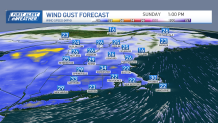
Wind will be kicking up as well out of the west with gusts up to 30mph at times, diminishing somewhat early Sunday night, but staying on the breezy side. Highs Sunday reach the 50s south, 40s north.
Local


The week starts out on the quiet and on the dry side with temps in the 40s, temperatures are expected to stay near or just below average, running in the 40s the rest of the week.
Have a great weekend!
