
A fast moving low pressure system is bringing a wintry mix to New England on Monday afternoon and evening
Snow is developing rapidly in the hills of northwestern Connecticut, western Massachusetts and most of Vermont early this afternoon.
Snow will come down moderate to heavily for a couple of hours as it moves swiftly across New Hampshire and Maine through dinner time.
On a line from about Hartford, Connecticut, to Worcester, Massachusetts, to Portsmouth, New Hampshire, and points south, any snow should change quickly to rain. We may even have some gusty downpours in southeastern Massachusetts around sunset.
Get New England news, weather forecasts and entertainment stories to your inbox. Sign up for NECN newsletters.
Rainfall amounts near the coast are about a third of an inch, while snowfall amounts in the higher elevations west and north are 3 to 6 inches.
Temperatures Monday afternoon will be near freezing north, to the low 40s south. Wind may gust past 35 mph from Narragansett Bay to Nantucket Sound and Massachusetts Bay early Monday evening.
We dry and clear out overnight, with temperatures falling back into the 20s and low 30s and black ice possible.
U.S. & World


Yet another front comes into New England on Tuesday with another batch of snow in western New England during mid-morning through early afternoon.
Another inch or two in the higher elevations is possible, with just a few flurries or rain showers east during the afternoon.
High temperatures Tuesday will be in the 30s north, low 40s south.
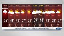
Another wave of low pressure will cross northern New England on Wednesday with a chance of snow in the mountains of northern Vermont, northern New Hampshire and western Maine. Another few inches are possible at the ski resorts.
At the same time in southern New England, maybe a rain shower or two with temperatures jumping to near 50 degrees under a mix of sun and clouds. Highs will be in the 30s to lower 40s north and central Wednesday afternoon.
We have yet another front Wednesday night and Thursday with a few snow showers possible, followed by windy and colder Thursday, with sunshine and highs in the 20s north and 30s south Thursday.
Friday looks quiet and cool.
A more significant storm system is likely to ride over New England on Saturday and Sunday, with a chance of some heavier rain and mountain snow later Saturday into early Sunday. It’s a busy weather pattern, with signs of spring beginning in southern New England, as seen in our First Alert 10-Day Forecast.
