
We’re following the hottest temperatures of this six-day heat wave Sunday afternoon, along with record-breaking temperatures in Boston that hadn't been broken in close to 90 years, and as well as severe weather across the region.
A tornado warning that was issued for part of Aroostook County in northern Maine through 7 p.m. has since expired; there was no immediate word if a tornado touched down anywhere.
There were several severe thunderstorm warnings issued Sunday night for parts of Maine, Vermont, Massachusetts, and Connecticut. Those have since expired. A new severe thunderstorm warning that was issued just after midnight for part of Grand Isle County in northwestern Vermont until 1:15 a.m. Monday has also expired.
Click here for active weather alerts in New England
Get New England news, weather forecasts and entertainment stories to your inbox. Sign up for NECN newsletters.
Boston has reached a high temperature of 100 degrees today -- you read that right -- surpassing the previous daily record of 98 degrees that was set in 1933. The last time Boston saw 100 degrees was June 30, 2021.
Weather Stories


Our heat advisories now stretch all the way through Cape Cod as our heat indices range from the 90s to the three digits. Sunny skies for most, while some showers and storms begin to develop across the northern states this evening. Some showers may also reach MA tonight. Lows drop to the upper 70s and our dew points remain high, which won’t bring any relief to this daytime heat.
Since our tropical environment continues through Monday, our other First Alert goes out to the chance for strong storms tomorrow.
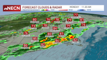
A cold front pushes south and brings lifting, where we’ll see our scattered potential for strong to severe storms moving south. With our previous event on Thursday, most storms stayed north and west, bringing no rain to the southeastern counties. This time, our thunderstorms will also bring a threat to the far southern areas of New England.
Main concern with Monday’s severe thunderstorms are damaging wind, hail, torrential rain and rotation. These storms will enhance the potential for tree damage, power lines, roofing and with the heavy rain some flash flooding may also be another factor to look out for.
Remain weather aware Monday as most storms will take place in the afternoon, the strongest activity may roll in during the evening commute hours. Visibility will likely be affected and driving under these conditions is not recommended. Plan ahead and stay tuned on your First Alert team who will keep you updated.
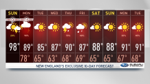
In our 10 day forecast you’ll find improving conditions by Tuesday, drier air will take over and sunny skies along with more normal temperatures will remain through Wednesday before our next chance for showers and storms returns on Thursday.
