
-
Temperatures could creep up to 80 by the weekend as a warmup heads our way
A pleasant warmup is coming our way in the First Alert forecast as high pressure takes control from the middle of the week through the weekend. We begin that warmup today, as highs rise to the mid-60s. Those highs jump into the upper 60s to middle 70s by Wednesday. Our temperatures will be a few degrees above where they...
-
Tracking Hurricane Hilary's path
Hilary strengthens to a Category 4 hurricane. Belen De Leon has the forecast for Friday Aug. 18, 2023.
-
The Coldest Air We've Had in Nearly 7 Years on the Way
We’ve been fortunate this winter with above average temperatures through much of the season. In fact, season-to-date, this is the seventh warmest winter thus far, and among the top five warmest Januarys on record. That comes to a screeching halt later this week. The first week of February will feature frigid temperatures and dangerous wind chills. The coldest temperature...
-
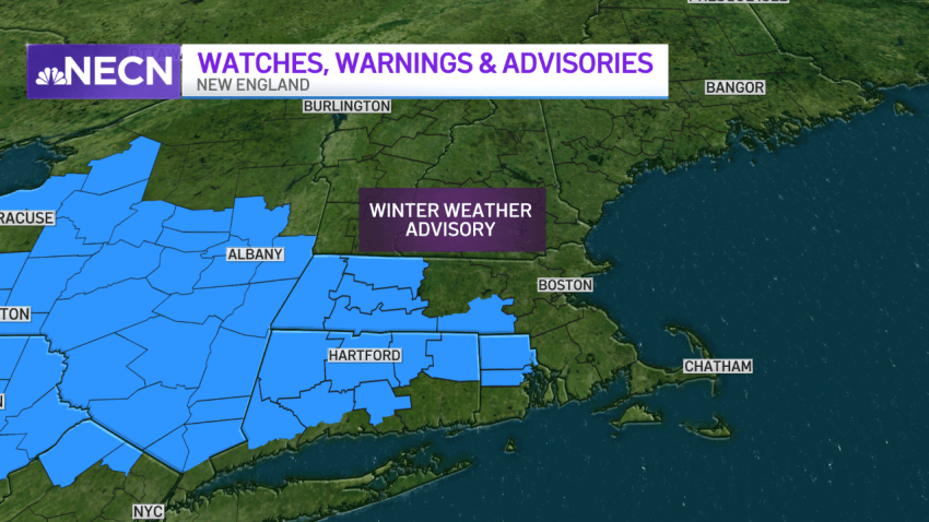
FIRST ALERT: Snowy, Slippery Roads For the Evening Commute and Gusty Winds Overnight
Rain and snow are moving in for the evening commute but it’s a different setup than Monday, with snow changing to rain. As a result, roads will be pre-treated. That’s not to be interpreted that slick roads won’t develop, because they will: a narrow band of light snow with little impact for most of Southern New England around midday...
-
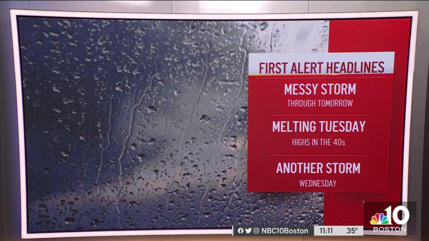
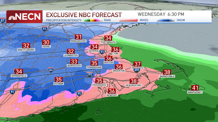
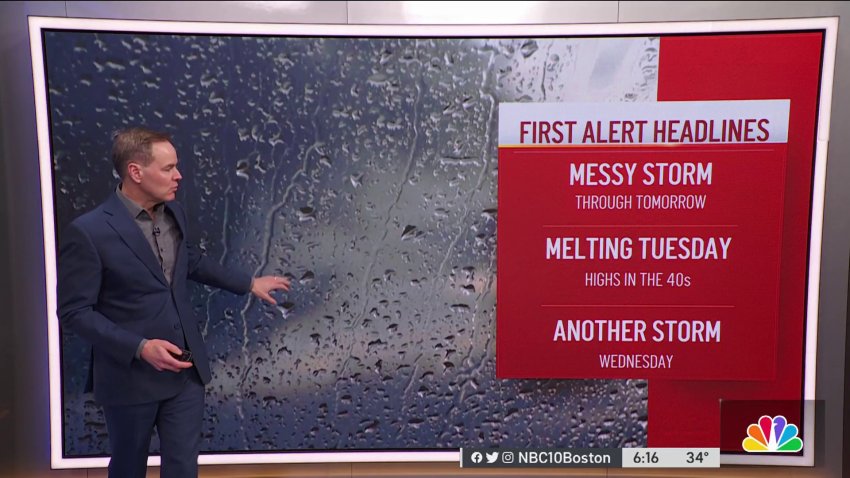
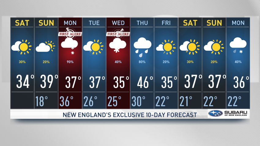
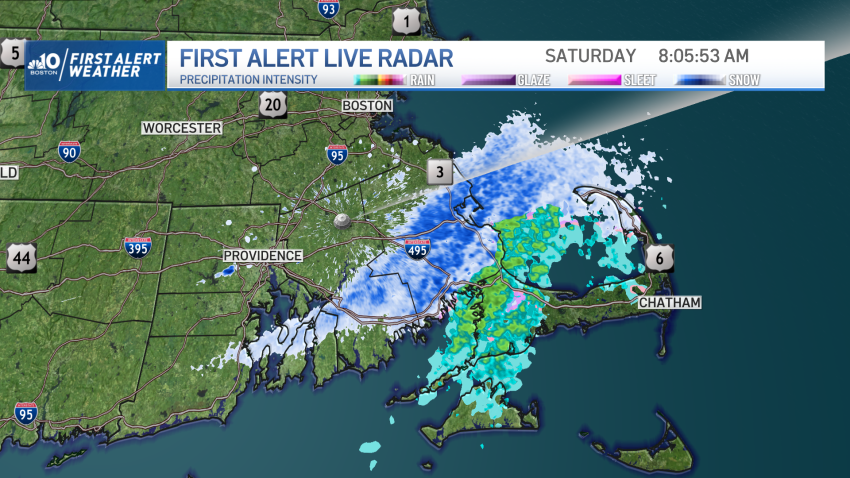
Forecast: Messy Winter Storm Lasts Through Monday
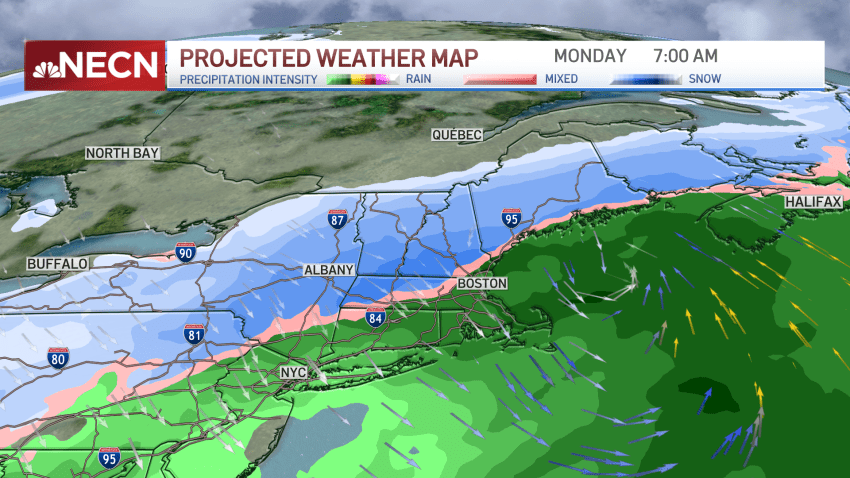
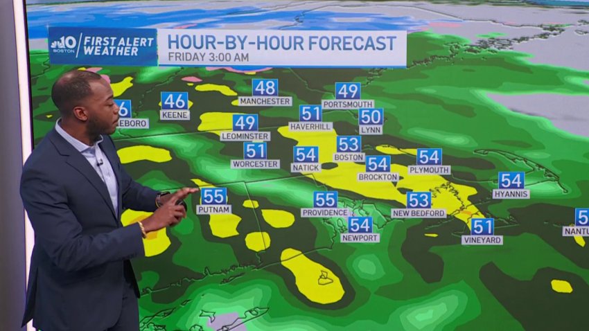
Sunday night: Rain and snow arrive. Areas East of I-495 and South of I-90 see mainly rain overnight. Lows in the middle 30s....
Monday: Rain in the morning East of I-495, then a change to snow for all areas in the afternoon. Widespread 1-3” East, as much as 4-8” well West. Highs upper 30s....
Monday Night: snow tapers, skies slowly clear. Colder... -
Forecast: Messy Winter Storm Through Monday
Sunday night: Rain and snow arrive. Areas East of I-495 and South of I-90 see mainly rain overnight. Lows in the middle 30s....
Monday: Rain in the morning East of I-495, then a change to snow for all areas in the afternoon. Widespread 1-3” East, as much as 4-8” well West. Highs upper 30s....
Monday Night: snow tapers, skies slowly clear. Colder... -
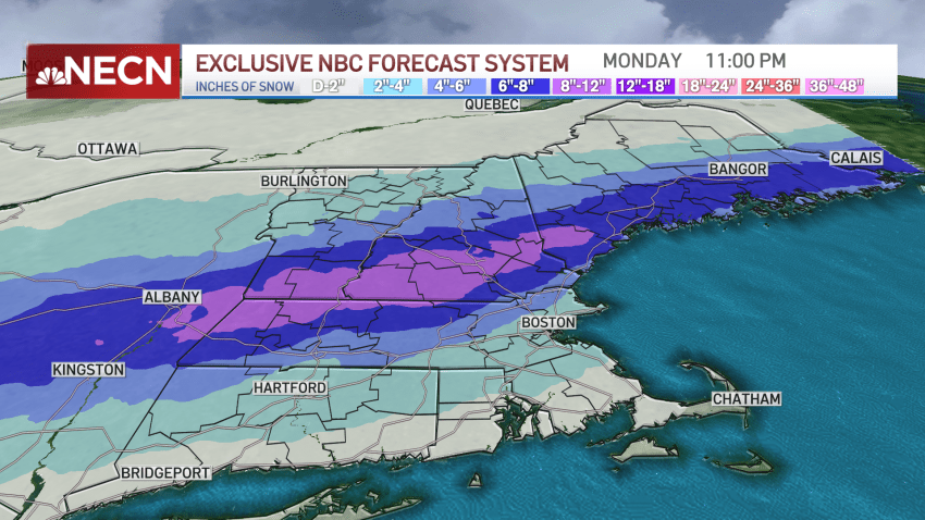
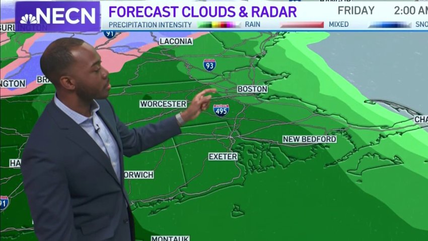
FIRST ALERT: Winter Storm Arrives in New England, Bringing Mix of Rain and Snow Through Monday
Expect snow to fall north and west of Interstate 495, and for most of New Hampshire, Vermont and Maine. Snow continues overnight North and West, while rain falls for Boston and southern New England.
-
Seasonable and Quiet Saturday in New England
It’s a seasonable day across New England with mostly quiet and calm conditions inland. Temperatures will top out in the upper 30s across southern New England. Increasing sun continues this afternoon with a quiet evening. It’s off in the coast where we’re tracking slightly higher seas coinciding with astronomical high tide allowing for coastal inundation to become a risk....
-
Cloudy Morning with Light Winds Before Cold Saturday Night
A colder, but seasonable day on Saturday with a mix of sun and clouds. Highs in the middle 30’s. Saturday night will be the coldest night in some time. Lows in the lower and middle 20’s with a partly cloudy sky. Sunday is cloudy, with rain arriving by late afternoon. Highs in the lower 40’s. Monday starts with rain heavy…
-
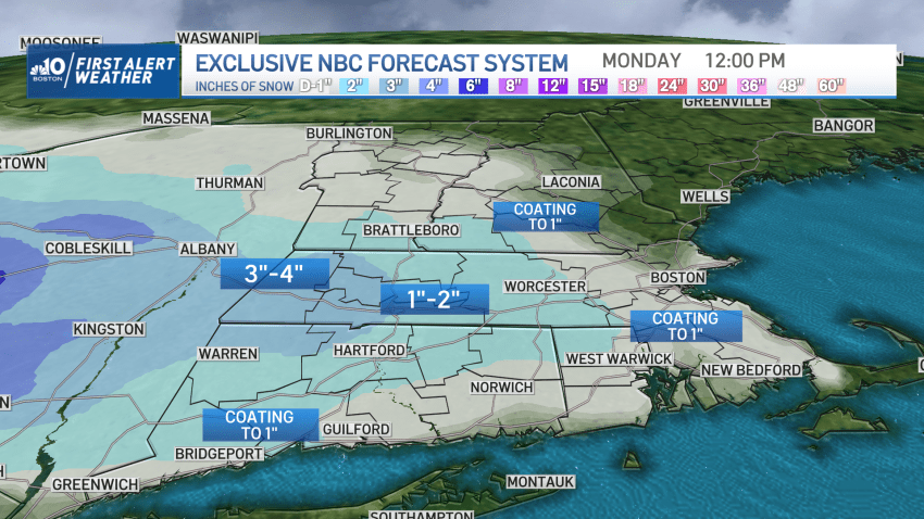
Next Storm Arrives Late Sunday – With More Accumulating Snow
Pockets of light snow and snow showers will be tapering off and ending this evening, but additional coatings of snow will be possible before the conclusion of this event. The biggest impact this evening and tonight will be the dropping temperatures – which will fall into the 20s for many (teens far North Country) and freeze leftover moisture on anything…
-
FIRST ALERT: Wet and Dreary With Snow Moving in For Some
Our dreary weather pattern continues tonight and for tomorrow, and on the bright side we finally see some wintry precipitation for winter lovers! Light snow is expected around Boston Friday afternoon. Temperatures begin to fall as we see a northeasterly breeze overnight tonight. Any residual moisture will freeze in place on untreated surfaces from drizzle or fog in northern...
-
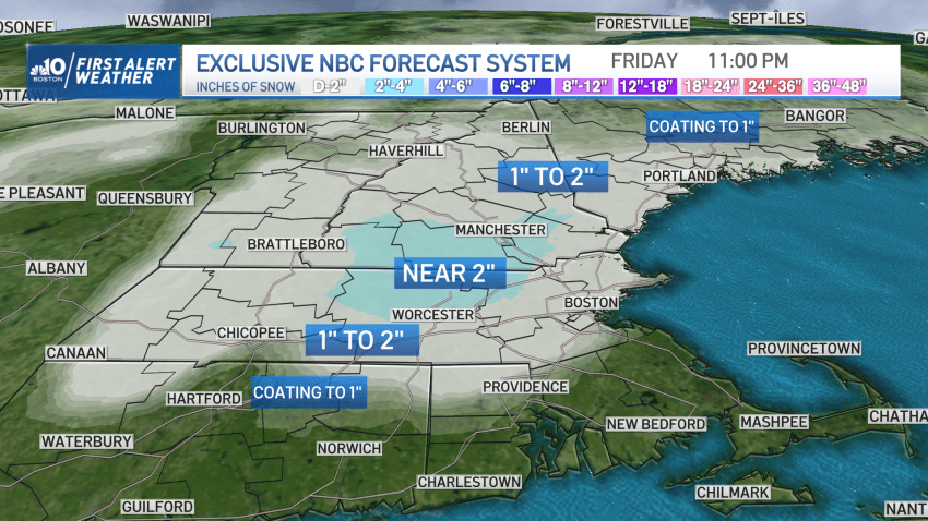
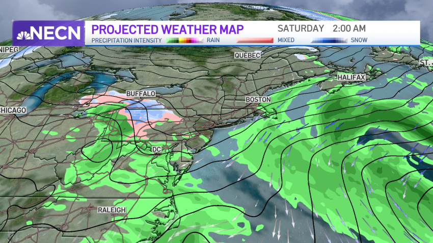
What to Expect from Friday's Winter Storm Hitting New England
We’re on the eve of the big storm. It’s been making headlines across the country for a couple of days now. Everything from extreme temp drops – from 51 to 0 in Denver – to blizzard-like conditions near the Twin Cities. Extreme cold won’t be the headliner here. However, we’ve definitely seen worse in that respect. However, we WILL get…
-
Forecast: Winter Storm Moving In on New England
Today (Wednesday): Sun & clouds. Highs near 40°. Overnight Wednesday Night: Calm, partly cloudy. Lows in the 20s. Thursday: Cloudy. Evening showers, night rain – night mountain snow. Highs around 40°.
-
Forecast: All Eyes on Storm Starting Late Thursday
Today (Wednesday): Sun & clouds. Highs near 40°. Overnight Wednesday Night: Calm, partly cloudy. Lows in the 20s. Thursday: Cloudy. Evening showers, night rain – night mountain snow. Highs around 40°.
-
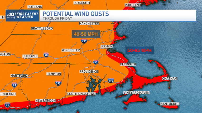
Strong Winds, Heavy Rain, Flash Freeze and Coastal Flooding All Possible With Friday's Storm
A strengthening storm will emerge from the Rocky Mountains later today and undergo rapid intensification as it crosses the central US tomorrow. Blizzard warnings and winter storm warnings/advisories have been issued from the areas of the mountainous west coast to parts of the eastern seaboard as this system will produce several impacts including damaging winds, heavy snow and flooding...
-
Forecast: Rain, Snow Continue Tonight
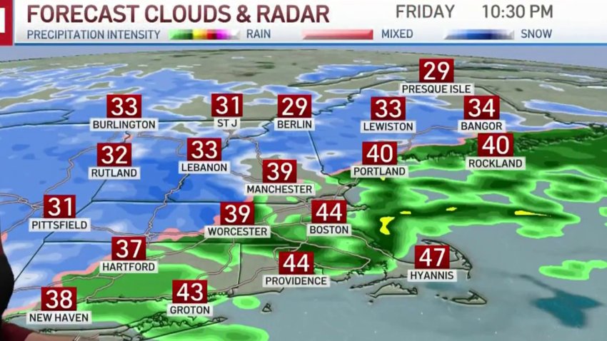
This Evening: Rain, heavy at times. Snow in high terrain & Northern/Western New England. Windy with isolated outages. Temps hold in the 40s, 30s north/west. Overnight Friday Night: Rain changes to snow showers before ending, snow continues north. Lows in the 30s. Saturday: Early pockets of snow depart for emerging sun. Highs around 40. Sunday: Fair, cool. Highs 35-40°.
-
Snow Now Falling in Parts of New England. See the Latest Snowfall Total Maps
Cloudy skies, cold temperatures, wind chills in the 20s and snow! That pretty much describes our Sunday. We’re tracking snow pushing out of western New England eastward. This snow may spread as far east as Boston but it will be limited and difficult to accumulate in eastern Mass. Worcester county may see up to an inch or two of...
-
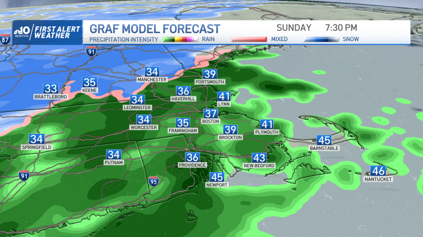
Wintry Weekend Before Possible Snow on Sunday Evening
Ocean-effect snow showers woke up residents in southeastern Massachusetts on Saturday while Cape Cod and the Islands have seen rain. Temperatures Saturday evening will drop, allowing for more of that snow to spread over eastern Mass., possibly bringing some snow over Boston and the North Shore. Early morning precipitation might continue in the northeast, but as it ends in the…
-
What's the Deal With the Snow This Weekend?
Parts of southern New England could see some snow this weekend. And while not everyone will see flakes, the temperatures across all of New England will come crashing down to the 20s and 30s tomorrow afternoon for us all. A north wind will keep the wind chills in the 20s tomorrow and the far northern communities in New Hampshire, Vermont…
-
It's Almost the Middle of December, So Where's the Snow and Cold?
Storms continue to push through New England in a similar fashion. They’re quick movers, produce gusty winds and mild temperatures. The one thing they’re lacking is snowfall. That may change this coming weekend. Colder air finally moves in starting Friday, but will it be too cold? Cold air is dry, and usually accompanied by high pressure. High pressure can...
Trending
